Wednesday, August 3, 2011

Rae Lakes Loop - Sequoia / Kings Canyon National Park, California

In August of 2011, some friends and I backpacked the popular Rae Lakes loop in Sequoia / Kings Canyon National Park.  We opted to hike it clockwise in order to give ourselves more time to acclimate before tackling the nearly 12,000 ft. Glen Pass.  The trail begins at Roads End on Hwy. 180 and the drive in along the Kings Canyon is spectacular.

Covering about 38 miles (NPS website says 46, Nat Geo Topo says 38) and going from 5,000 to almost 12,000 ft. and back, we were shocked to encounter people attempting to run the loop in a day.  Seeing that they only had bananas and water I hope they made it!  Since the route is quite popular, you should make reservations early or be prepared to show up early for some first-come-first-served quota action.

Highlights of the trip included very social deer (stalking us for our salt emissions), amazing valleys, swimming in the incredible Rae Lakes, dipping toes in nearly frozen lakes over the pass, and conquering the still very snowy and steep Glen Pass.


Bridge on Rae Lakes Loop

Big Pinecones!

Rae Lakes Loop Bathroom, California, Kings Canyon National Park
Throne with a View

Rae Lakes Loop, King Canyon/Sequoia National Park

Rae Lakes Loop, King Canyon/Sequoia National Park
First Glimpse of Rae Lakes Area

Rae Lakes Loop, King Canyon/Sequoia National Park

Ranger Station Resupply

Rae Lakes Loop, King Canyon/Sequoia National Park
Rae Lakes Reflection

Glen Pass, Rae Lakes Loop, King Canyon/Sequoia National Park
Glen Pass

Glen Pass, Rae Lakes Loop, King Canyon/Sequoia National Park
Up to Glen Pass

Glen Pass, Rae Lakes Loop, King Canyon/Sequoia National Park
Last Bit to Glen Pass

Rae Lakes Loop, King Canyon/Sequoia National Park

Glen Pass, Rae Lakes Loop, King Canyon/Sequoia National Park
Coming Down

Cold Lake near Glen Pass, Rae Lakes Loop, King Canyon/Sequoia National Park
Cold!

Rae Lakes Loop, King Canyon/Sequoia National Park
Rae Lakes Loop Panarama

Deer, Rae Lakes Loop, King Canyon/Sequoia National Park
Nosy Neighbors

Rae Lakes Loop, King Canyon/Sequoia National Park

Rae Lakes Loop, King Canyon/Sequoia National Park

Rae Lakes Loop, King Canyon/Sequoia National Park


View Rae Lakes in a larger map


California Readers: Interested in getting paid to unplug your laptop or turn off a light for an hour? $20 just for joining OhmConnect, learn more at: https://login.ohmconnect.com/ref/30315

Wednesday, June 15, 2011

Andorra Hikes

Back in June 2011, Angela and I did two great hikes in Andorra as part of a larger trip around Europe.  Something like 80% of Andorra is owned by ski resorts, but there are still some beautiful less-touched valleys to explore.  One very interesting thing about hiking or backpacking in Andorra, and I imagine elsewhere in Europe, is the presence of "refugi" or refuges, which are cabins you can stay in.  Many of them even have restaurants or at least drinks and snacks available for purchase.

The first hike left out of Arinsal in the west of the country.  You can get most places using the bus system, but this can leave you with some extra miles hiking on roads.  Our original goal was to get to the highest point in Andorra, Coma Pedrosa and the point nearby where Spain, France, and Andorra meet.  We changed our minds pretty shortly after starting the hike (green line on map below) and decided to head west up to the Refugi De Coma Pedrosa (at end of blue line).  This Refugi is situated in a scenic valley and by a small mad-made lake.  It offers beds to sleep on and also has sandwiches, soups, and drinks.  After eating lunch there, we continued uphill to a ridge that took us briefly into Spain before heading back down into Arinsal via the seasonally abandoned Valnord ski slopes (red line).

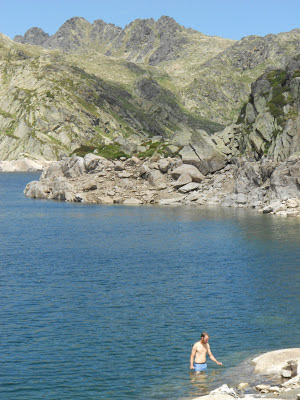
After taking a day to relax, we did a second hike in the eastern part of the country up the Vall d'Incles.  Using the bus system added about four miles to our hike, but the entire valley was so scenic we didn't mind.  This hike was much more popular than our first, likely due to a lower starting elevation and lower elevation gain.  The first part of this hike (green section) is not very steep as it heads up the beautiful pastoral valley for about 2 miles along the road.  As you leave the road behind, the trail gets rockier and steeper (blue section).  After another 1.5 miles and a ~1,300' gain in elevation, you come to the Refugi de Jucia near the shores of two lakes, Estany Primer de Juclar and Estany Segon de Juclar.  Angela enjoyed her time here by reading a book and relaxing at the refugi, while I swam in the frigid lake (a backpacking tradition of mine) and hiked up to the top of the ridge on the far side of the lakes which marks the border with France.

Andorra hike trail
Andorra hike trail Refugi De Coma Pedrosa Johnnie Chamberlin
Food Selection at Refugi De Coma Pedrosa

Refugi Coma Pedrosa Andorra hike trail

Andorra hike trail

Andorra hike trail


Wildflowers Andorra hike trail


Andorra hike trail

Andorra hike trail

ski lift Andorra hike trail

Vall d'Incles Andorra hike trail
Vall d'Incles

Andorra hike trail

Andorra hike trail

Estany de Juclar Andorra hike trail
Estany de Juclar

Estany de Juclar mountains lake Andorra hike trail


Arinsal - Refugi De Coma Pedrosa Hike

View Andorra Hikes in a larger map

Vall d'Incles Hike

View Andorra Hikes in a larger map

Wednesday, February 2, 2011

Bad Hiking, Camping, and Backpacking Jokes

I love horrible puns and started this piece mostly to exercise my brain. I started this in 2015, but have changed the date so only people who've searched for bad jokes will come across it, thus sparing any regular readers I may have from having to see these.

Here goes.

What is the laziest trail in the United States?
The Pacific Rest Trail
(Very different from the rugged 2,650 mile long trail through the mountains of California, Oregon, and Washington.)


What is the cleanest trail in Arkansas?
The Wash-it-all Trail.
Cleaner, but less scenic than the Ouachita Trail.


Can you float the Buffalo this time of year?
I dunno canoe?


Boyle Park and Burns Park are so hot right now. 
(These are city parks in Little Rock)


"Coming home with medals in scenery, habitat diversity, and precipitation... Olympic National Park everybody!"

That's all for now. More to come, or maybe not!


Wednesday, July 1, 2009

Peru Hikes

I went to Peru in 2009 and am writing this years after the fact, so this post will be pretty general and photo-heavy.

We did two big treks in Peru: The Salkantay Trail to Machu Picchu and the Santa Cruz Trek over Punta Union Pass near Huaraz.  Prior to hiking, we took a few days to acclimatize by going from Lima to Arequipa (7,600 ft.) and then to Cusco (11,100 ft.).  There are lots of interesting things to see and do in Arequipa, Cusco, and Huaraz, so taking a few days to adjust to the elevation is not boring and comes highly recommended.  We felt the elevation but didn't get sick.  Some tourists in our group got VERY sick and it wasn't surprising to hear they'd flown in from Lima just the day before starting their trek.  

There are multiple routes to trek to Machu Picchu and they are being added/rerouted all the time so do your research.  We chose the Salkantay Trail because it was supposed to offer more in terms of scenery and natural wonder.  The Inca Trail is thought to have better cultural offerings.
Having only done the Salkantay, I can't compare the two, but I was perfectly happy with our choice.

We got to Machu Picchu early in the morning in order to get a limited spot to hike more of the site.  This additional area was very strenuous and felt pretty dangerous at times with lots of ropes and old ladders along the route.

I loved the city of Huaraz and would love to go back.  It has great cafes and restaurants and is surrounded by mountains.  Our trek over Punta Union Pass had some incredible scenery and let us experience an extreme elevation of 15,500 ft.

On both treks we were given coca tea in the morning.  We also bought leaves to chew along the way.  There is some debate about whether the leaves help with elevation acclimatization or just with the symptoms of altitude sickness.  If you don't want to use the local strategy, you should do some research on other meds or using ibuprofen or naproxen to prevent altitude sickness.

Arequipa Airport