This year has been a big one for bridge building in Little Rock. The Big Dam bridge got a baby brother this summer when the Little Maumelle bridge was completed. This attractive and already heavily used bridge connects an extension of the River Trail to Two Rivers Park. For most Little Rockians, this makes Two Rivers Park much more accessible, as people living in Riverdale, The Heights, and Hillcrest can now bike to Two Rivers in less time than it would take them to drive.
Down the river on the other side of town, the Junction Bridge is expecting a sibling as well. The Rock Island bridge is getting a face-lift and will soon play host to bikers and pedestrians travelling between Little Rock and North Little Rock or making the River Trail loop. Unlike the Junction Bridge, this bridge has a continuous ramp, so bikers will no longer have to dismount and take lots of stairs or an elevator to get across the river.
These bridges and the trails they connect, will have (and are already having) a major positive impact on the quality of life and health of the citizens of Little Rock and North Little Rock.
Where should the next bridge be built? Somewhere over Fourche Creek? Between the Big Dam Bridge and the Junction Bridge? Or would that money be better spent helping pave some of the many proposed trails out there?
Sunday, September 4, 2011


Trails in Little Rock - Going Beyond Recreation
Little Rock has spent a lot of money on trails and will hopefully and likely continue to do so for years to come. So far, most of these trails are short and disconnected, making the suitable only for recreation and not for commuting. One major exception to this is the River Trail. Lots of people use it for recreation, but a sizable number of people also use it to get to work without hopping in a car. Given the health benefits of walking and biking, and the negative impacts of driving (traffic, air pollution, road rage, greenhouse gas emissions...) wouldn't it be great if our community expanded other trails and connected them to the River Trail in order to make it easier for more people from more locations in the city to get places safely by bike or foot?
Some neighborhoods are already working to make this happen. The Stift Station/Capitol View neighborhood has plans for a paved trail along Rose Creek that would connect the neighborhood to the River Trail, giving residents a scenic and safe way to get downtown while avoiding automobiles.
UALR and Little Rock Parks are working on a trail along Coleman Creek that would connect residential, commercial, and park areas to the University in Midtown.
Rock Creek, which flows from Chenal Valley essentially to UALR, already has multiple sections of paved trail along its banks. If these sections were connected, people in West Little Rock would be able to bike between their homes and nearby shopping areas or even all the way to Midtown without having to share busy streets with speeding cars.
The map below shows what these connections might look like. If you like any of these ideas be sure to share them with your friends and elected officials.
Some neighborhoods are already working to make this happen. The Stift Station/Capitol View neighborhood has plans for a paved trail along Rose Creek that would connect the neighborhood to the River Trail, giving residents a scenic and safe way to get downtown while avoiding automobiles.
UALR and Little Rock Parks are working on a trail along Coleman Creek that would connect residential, commercial, and park areas to the University in Midtown.
Rock Creek, which flows from Chenal Valley essentially to UALR, already has multiple sections of paved trail along its banks. If these sections were connected, people in West Little Rock would be able to bike between their homes and nearby shopping areas or even all the way to Midtown without having to share busy streets with speeding cars.
The map below shows what these connections might look like. If you like any of these ideas be sure to share them with your friends and elected officials.
Wednesday, August 3, 2011
Rae Lakes Loop - Sequoia / Kings Canyon National Park, California
In August of 2011, some friends and I backpacked the popular Rae Lakes loop in Sequoia / Kings Canyon National Park. We opted to hike it clockwise in order to give ourselves more time to acclimate before tackling the nearly 12,000 ft. Glen Pass. The trail begins at Roads End on Hwy. 180 and the drive in along the Kings Canyon is spectacular.
Covering about 38 miles (NPS website says 46, Nat Geo Topo says 38) and going from 5,000 to almost 12,000 ft. and back, we were shocked to encounter people attempting to run the loop in a day. Seeing that they only had bananas and water I hope they made it! Since the route is quite popular, you should make reservations early or be prepared to show up early for some first-come-first-served quota action.
Highlights of the trip included very social deer (stalking us for our salt emissions), amazing valleys, swimming in the incredible Rae Lakes, dipping toes in nearly frozen lakes over the pass, and conquering the still very snowy and steep Glen Pass.


California Readers: Interested in getting paid to unplug your laptop or turn off a light for an hour? $20 just for joining OhmConnect, learn more at: https://login.ohmconnect.com/ref/30315
Covering about 38 miles (NPS website says 46, Nat Geo Topo says 38) and going from 5,000 to almost 12,000 ft. and back, we were shocked to encounter people attempting to run the loop in a day. Seeing that they only had bananas and water I hope they made it! Since the route is quite popular, you should make reservations early or be prepared to show up early for some first-come-first-served quota action.
Highlights of the trip included very social deer (stalking us for our salt emissions), amazing valleys, swimming in the incredible Rae Lakes, dipping toes in nearly frozen lakes over the pass, and conquering the still very snowy and steep Glen Pass.


 |
| Big Pinecones! |
 |
| Throne with a View |

 |
| First Glimpse of Rae Lakes Area |

 |
| Ranger Station Resupply |
 |
| Rae Lakes Reflection |
 |
| Glen Pass |
 |
| Up to Glen Pass |
 |
| Last Bit to Glen Pass |

 |
| Coming Down |
 |
| Cold! |
 |
| Rae Lakes Loop Panarama |
 |
| Nosy Neighbors |


View Rae Lakes in a larger map

California Readers: Interested in getting paid to unplug your laptop or turn off a light for an hour? $20 just for joining OhmConnect, learn more at: https://login.ohmconnect.com/ref/30315
Wednesday, June 15, 2011
Andorra Hikes
Back in June 2011, Angela and I did two great hikes in Andorra as part of a larger trip around Europe. Something like 80% of Andorra is owned by ski resorts, but there are still some beautiful less-touched valleys to explore. One very interesting thing about hiking or backpacking in Andorra, and I imagine elsewhere in Europe, is the presence of "refugi" or refuges, which are cabins you can stay in. Many of them even have restaurants or at least drinks and snacks available for purchase.
The first hike left out of Arinsal in the west of the country. You can get most places using the bus system, but this can leave you with some extra miles hiking on roads. Our original goal was to get to the highest point in Andorra, Coma Pedrosa and the point nearby where Spain, France, and Andorra meet. We changed our minds pretty shortly after starting the hike (green line on map below) and decided to head west up to the Refugi De Coma Pedrosa (at end of blue line). This Refugi is situated in a scenic valley and by a small mad-made lake. It offers beds to sleep on and also has sandwiches, soups, and drinks. After eating lunch there, we continued uphill to a ridge that took us briefly into Spain before heading back down into Arinsal via the seasonally abandoned Valnord ski slopes (red line).
After taking a day to relax, we did a second hike in the eastern part of the country up the Vall d'Incles. Using the bus system added about four miles to our hike, but the entire valley was so scenic we didn't mind. This hike was much more popular than our first, likely due to a lower starting elevation and lower elevation gain. The first part of this hike (green section) is not very steep as it heads up the beautiful pastoral valley for about 2 miles along the road. As you leave the road behind, the trail gets rockier and steeper (blue section). After another 1.5 miles and a ~1,300' gain in elevation, you come to the Refugi de Jucia near the shores of two lakes, Estany Primer de Juclar and Estany Segon de Juclar. Angela enjoyed her time here by reading a book and relaxing at the refugi, while I swam in the frigid lake (a backpacking tradition of mine) and hiked up to the top of the ridge on the far side of the lakes which marks the border with France.

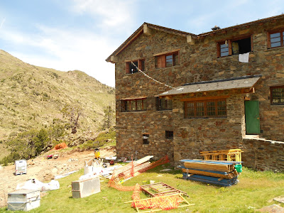



The first hike left out of Arinsal in the west of the country. You can get most places using the bus system, but this can leave you with some extra miles hiking on roads. Our original goal was to get to the highest point in Andorra, Coma Pedrosa and the point nearby where Spain, France, and Andorra meet. We changed our minds pretty shortly after starting the hike (green line on map below) and decided to head west up to the Refugi De Coma Pedrosa (at end of blue line). This Refugi is situated in a scenic valley and by a small mad-made lake. It offers beds to sleep on and also has sandwiches, soups, and drinks. After eating lunch there, we continued uphill to a ridge that took us briefly into Spain before heading back down into Arinsal via the seasonally abandoned Valnord ski slopes (red line).
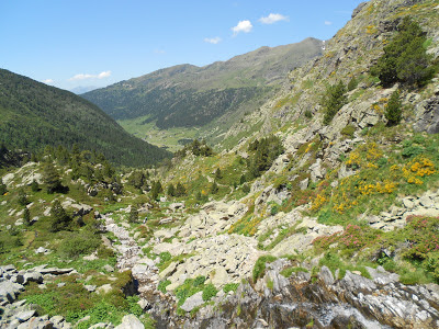
After taking a day to relax, we did a second hike in the eastern part of the country up the Vall d'Incles. Using the bus system added about four miles to our hike, but the entire valley was so scenic we didn't mind. This hike was much more popular than our first, likely due to a lower starting elevation and lower elevation gain. The first part of this hike (green section) is not very steep as it heads up the beautiful pastoral valley for about 2 miles along the road. As you leave the road behind, the trail gets rockier and steeper (blue section). After another 1.5 miles and a ~1,300' gain in elevation, you come to the Refugi de Jucia near the shores of two lakes, Estany Primer de Juclar and Estany Segon de Juclar. Angela enjoyed her time here by reading a book and relaxing at the refugi, while I swam in the frigid lake (a backpacking tradition of mine) and hiked up to the top of the ridge on the far side of the lakes which marks the border with France.

 |
| Food Selection at Refugi De Coma Pedrosa |


 |
 |


 |
| Vall d'Incles |


 |
| Estany de Juclar |

Arinsal - Refugi De Coma Pedrosa Hike
View Andorra Hikes in a larger map
Vall d'Incles Hike
View Andorra Hikes in a larger map
Wednesday, February 2, 2011
Bad Hiking, Camping, and Backpacking Jokes
I love horrible puns and started this piece mostly to exercise my brain. I started this in 2015, but have changed the date so only people who've searched for bad jokes will come across it, thus sparing any regular readers I may have from having to see these.
Here goes.
What is the laziest trail in the United States?
The Pacific Rest Trail
(Very different from the rugged 2,650 mile long trail through the mountains of California, Oregon, and Washington.)
What is the cleanest trail in Arkansas?
The Wash-it-all Trail.
Cleaner, but less scenic than the Ouachita Trail.
Can you float the Buffalo this time of year?
I dunno canoe?
Boyle Park and Burns Park are so hot right now.
Here goes.
What is the laziest trail in the United States?
The Pacific Rest Trail
(Very different from the rugged 2,650 mile long trail through the mountains of California, Oregon, and Washington.)
What is the cleanest trail in Arkansas?
The Wash-it-all Trail.
Cleaner, but less scenic than the Ouachita Trail.
Can you float the Buffalo this time of year?
I dunno canoe?
Boyle Park and Burns Park are so hot right now.
(These are city parks in Little Rock)
"Coming home with medals in scenery, habitat diversity, and precipitation... Olympic National Park everybody!"
That's all for now. More to come, or maybe not!
"Coming home with medals in scenery, habitat diversity, and precipitation... Olympic National Park everybody!"
That's all for now. More to come, or maybe not!
Subscribe to:
Posts (Atom)