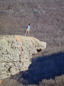
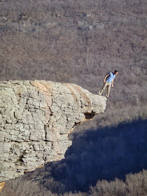
I've always felt a little insecure about considering myself an outdoorsy Arkansan or an expert on trails in Arkansas while having never been to one of the places that helps define The Natural State via book covers, postcards, and frequent appearances in tourist-seeking TV commercials. I'm speaking, of course, about Hawksbill Crag, aka Whitaker Point, located near Ponca. This past weekend, I finally remedied that awkward situation by making my pilgrimage.
To get to the trailhead, turn west onto the dirt road at the bridge over the Buffalo on Hwy. 21 (six miles south of Ponca, 10 miles south of Kingston, 1.1 mi. south of the Hwy. 21/ Hwy. 43 intersection). There are several bridges in the area, so make sure you are at the one that crosses the Buffalo River. On maps the road is shown as 5 or Cave Mountain Springs Rd., but don't expect to see a sign calling it that at the turn. I encourage you to use the interactive map below and read multiple
online driving directions before making the trip. The road is fairly well maintained, but it is very steep and clayey, so don't try it shortly after a rain unless you have the right vehicle for the job.
The roughly 3.5 mi. roundtrip trail heads east and downhill from the trailhead/parking area. After crossing a small stream, the trail eventually levels out. As you make your way down the trail, the beech (somewhat rare in Arkansas), oak, and hickory forest gives way to pine along the bluff edge. Be sure to follow the orange triangle blazes as there are several old or unofficial trails in the area. Along the rim, you'll come across a waterfall and then the main event. There are a couple great spots to take photos of Hawksbill Crag just up the trail from the rocky outcropping. Just past the Crag, is a smaller version with a small rock arch on top. When done taking photos, return back to the trailhead the way you came. Much of the land in the area is private property and following unlabeled trails could lead to trespassing.


No comments:
Post a Comment