Pages

Monday, January 20, 2014

Hawksbill Crag

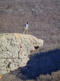
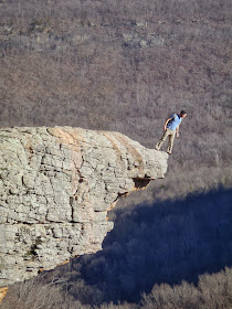
I've always felt a little insecure about considering myself an outdoorsy Arkansan or an expert on trails in Arkansas while having never been to one of the places that helps define The Natural State via book covers, postcards, and frequent appearances in tourist-seeking TV commercials.  I'm speaking, of course, about Hawksbill Crag, aka Whitaker Point, located near Ponca.  This past weekend, I finally remedied that awkward situation by making my pilgrimage.

To get to the trailhead, turn west onto the dirt road at the bridge over the Buffalo on Hwy. 21 (six miles south of Ponca, 10 miles south of Kingston, 1.1 mi. south of the Hwy. 21/ Hwy. 43  intersection).  There are several bridges in the area, so make sure you are at the one that crosses the Buffalo River.  On maps the road is shown as 5 or Cave Mountain Springs Rd., but don't expect to see a sign calling it that at the turn.  I encourage you to use the interactive map below and read multiple online driving directions before making the trip.  The road is fairly well maintained, but it is very steep and clayey, so don't try it shortly after a rain unless you have the right vehicle for the job.

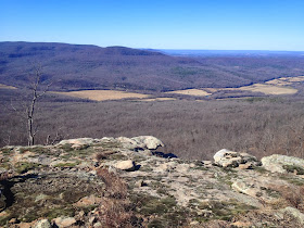
The roughly 3.5 mi. roundtrip trail heads east and downhill from the trailhead/parking area.  After crossing a small stream, the trail eventually levels out.  As you make your way down the trail, the beech (somewhat rare in Arkansas), oak, and hickory forest gives way to pine along the bluff edge.  Be sure to follow the orange triangle blazes as there are several old or unofficial trails in the area.  Along the rim, you'll come across a waterfall and then the main event.  There are a couple great spots to take photos of Hawksbill Crag just up the trail from the rocky outcropping.  Just past the Crag, is a smaller version with a small rock arch on top.  When done taking photos, return back to the trailhead the way you came.  Much of the land in the area is private property and following unlabeled trails could lead to trespassing.  

The Bridge of the Buffalo - Turn here.

Follow these Blazes

First Glimpse of the Crag


Hawk Bill Crag Whitaker Whiteacre Point Pt. Arkansas Buffalo River
About as brave as I got.  It was WINDY!
What I imagine it would have looked like if I had a parachute on my back.


View Hawksbill Crag in a larger map


Sunday, January 19, 2014

New Trails Coming to Walker Park

Update 1/20/15: The disc golf course is still not installed, but the course has been cleared. Walker Park is now connected to the Frisco Trail/Razorback Greenway and it will soon be extended under 15th and head west near Cato Springs Rd. out to Mt. Kessler.

Update 1/22/14: Ok the "trails" below are a disc golf course!  The Frisco Trail extension is still coming in to the west side of the park near the skate park and it will connect to the existing Walker Park trails.

I haven't verified this with anyone at the City, but I think there are some new trails coming to Walker Park.  On a recent trip to the park, I noticed some large cleared paths through the woods in the northern half of the park.  After following them around, it became clear that these weren't sewer or gas pipeline right-of-ways.  The map below shows the route we took, but I think there were some more trails in there.  Some sections were wide, which made me think they will eventually be paved, while others were thin, which may mean they are destined to be dirt paths.  The wooded areas of Walker Park are great places to add nature trails or beginner mountain biking trails.  With the coming connection to the Razorback Greenway/Frisco Trail, Walker Park will see more visitors from all around the area making adding some new recreational opportunities to the park seem like a great idea.


View New Walker Park Trails in a larger map

Wednesday, January 15, 2014

Walkability Ranking of Arkansas Cities and Neighborhoods

This blog focuses on getting people outside and active.  My books and blog articles have an emphasis on trails located in and near heavily populated areas of the state.  I also frequently write about the future of trails as part of an alternative/active transportation system that allows people to break their dependence on cars to accomplish everyday tasks like getting to work or buying groceries.  "Walkability" is a popular newish term that attempts to quantify how easy it is to do things without using a car.  If your neighborhood has lots of mixed-use developments with housing, shopping, restaurants, and office buildings nearby then it will have a high walkability score.  If you live in stereotypical suburbia with just homes and subdivisions as far as the eye can see (or the feet can walk) then your area will have a low walkability score since you need a car to get anywhere.

Here is a list of cities and neighborhoods ranked by walkability score.  Scores and maps are from http://www.walkscore.com/    The site also has similar scoring systems for transit and biking which I will cover in the future.  Let me know in the comments any cities you want me to add!
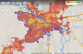
Little Rock Walkability Map
Little Rock Walkability Map - From Walkscore.com
Examples: 
New York City - 88
Berkeley, CA - 79
Houston - 44
Memphis - 33
Tulsa - 36
Austin - 35

Arkansas Cities:
Fayetteville Walkability Map - From Walkscore.com
Eureka Springs - 70's (I could only get scores for specific addresses in town, so this may be skewed high, still no wonder why everyone loves visiting!)
Conway Walkability Map - From Walkscore.com
Fort Smith - 33
North Little Rock - 32
Little Rock - 31
Hot Springs - 29
Fayetteville - 27
Texarkana - 27
Conway - 25
Bentonville - 24
Pine Bluff - 23
Springdale - 23
Jonesboro - 21
Rogers - 18
Maumelle - 16
Bryant - 15

Note: While cities like Fort Smith and Little Rock have scores twice as high as places like Maumelle and Bryant, scores in the 30's are still considered very low and earn cities the label of "Car-Dependent".  This label shouldn't surprise anyone living in any of these cities.

Best Arkansas Neighborhoods:

Little Rock:
Downtown ranks the highest reaching the 90's (but I think it could stand more housing options)
Fort Smith Walkability Map - From Walkscore.com
Honorable Mentions: Argenta, Heights, Hillcrest, and some surprising (to me) spots in WLR around W. Markham/Bowman/Chenal and Rodney Parham/Treasure Hills

Fayetteville: 
Downtown/Dickson St./MLK  Area scores in the 80's
One I didn't think of: the area along Township between College and Gregg ranked highly as well.

Eureka Springs:
Main St. scores in the high 70's

Springdale:
Highest around Emma/Holcomb/Thompson/Maple area (Low 60's)


Monday, January 13, 2014

Arkansas' Best Colleges for Outdoorsy People - Help Needed

I've wanted to do this article (and one ranking Bike-Friendly Campuses) for awhile now, but in order to do it right I planned to send out lots of surveys to campuses around the state, wait for feedback, analyze the data and then write it up.  Since this blog is a hobby that produces no income, I haven't gotten around to putting the time in on that.  Instead of waiting for lots of free time, I've decided to publish an incomplete article and solicit help filling it out.  If you are a student or recent graduate of any college/university in Arkansas, please respond to the survey questions below using the comment section or the contact form here.

Here is my draft ranking of Arkansas' Best Colleges for Outdoorsy People that will surely change as results come in from schools I haven't ever visited.  Rankings are based on trails and facilities owned/built by the school and on nearby resources such as state parks, great climbing spots, etc.  Since one of the goals of this piece is to encourage schools to compete for outdoorsy students by improving and expanding their hiking, biking, climbing, paddling, and swimming infrastructure; extra weight is given to projects and facilities owned or supported by the school.

Let me know what I got wrong and what I'm missing!

Point Peter Mountain Trails - Buffalo National River

Today I tried to explore some lesser known trails inside the Buffalo River National Park boundaries.  The Point Peter area, on the east side of Richland Valley, south of Woolum, is accessible only by improved dirt road, but has some fantastic views of Searcy County, Richland Creek, and the National Park.  We attempted to find and hike 3 primitive trails along Richland Rd./Searcy Co. 12 and on the first pass, we were able to find one and hike part of it. With more careful searching we found the other two, and hiked part of one of those.

The area appeared to have suffered from ice and/or wind damage in recent history and the trails have not been cleared, making them difficult to find and follow and rough to hike on. On the positive side, the ice, wind, and evident fire have given the area a special feel, leaving an open forest of stunted irregularly formed pines and hickories.

All three trails appeared to be old road beds and the trail to Point Peter Mountain follows a maintained dirt road for the first half.  The map below shows the trails we looked for.  Red indicates a trail we didn't hike and blue shows sections we did.

The easternmost and highest of the three trails was the easiest to find and the easiest to follow (at least initially).  It also had the best views, though the middle trail might have had nice views of the Buffalo at the end.  I hope to return in the early spring or fall and take in the scenery while searching for the trail or just following the bluff line to the northern tip of Point Peter Mountain.

If you are looking for easier to locate hiking in the area, the Ozark Highlands Trail and Buffalo River Trail pass nearby.

More Specific Location Information for Point Peter Trail Trailheads:
The highest, easternmost trail:  Easy to spot, park at gate near Point Peter Rd. sign.
35.919067, -92.866135

The longer, middle trail: A little downhill from the big bend in the road when heading west from Point Peter Rd.  There is a small pullout area and look for signs of an old road bed.  35.927685, -92.873699

The short, westernmost trail: Near a powerline crossing.  35.925526, -92.876520
Old Rock Walls on Point Peter Mountain

View from East Side of Point Peter Mountain (Rollins Point).
The power line would make a great zipline!


View of Richland Valley from Point Peter Mountain - Johnnie Chamberlin
View of Richland Valley from Point Peter Mountain

View of Richland Valley from Point Peter Mountain

A Common Sight Along These Trails


View Point Peter Area Trails in a larger map

Wednesday, January 8, 2014

Frisco Trail / Razorback Greenway Extension Under MLK Almost Done

Update 3/19/14: Done!  You can now pass under MLK on the trail.  The trail extensions described below are underway, but currently you can't really go much of anywhere after using the tunnel.

I've been trying to find a good time to photograph the tunnel progress, and a recent trip to the Farmer's Co-op for a snow shovel and local eggs provided a perfect opportunity.  The tunnel under MLK will help connect much of south Fayetteville to the Frisco Trail and greater Razorback Greenway.  City plans for the trail show it forking south of the tunnel with one branch connecting to the Walker Park trails and the other paralleling MLK to pull in traffic from all the new large apartment complexes.  This will allow residents of those complexes a safe way to get to campus and Dickson St. by bike or by foot instead of having to battle traffic and fight for parking.