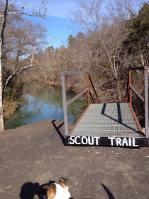
If you ever get tired of sitting in your car as you make the journey from Little Rock to Fayetteville, considering stopping in Clarksville and exploring the trails around Spadra Creek. While there are other access points, the one closest to I-40 is located behind the McDonald's on Rogers St. (at exit #58). From the parking area, you have several dirt trail options, most of which are used by mountain bikers, and a long flat paved trail. The map below shows the paved trail and hopefully I will add some of the dirt trails on future visits. From the parking area near the interstate, the trail roughly follows Spadra Creek for 1.75 miles up to the University of the Ozarks. The trail is mostly forested at the beginning and then gets progressively more open. I believe the mountain biking trails are mostly in the woods, if you are looking for a more natural feel.
Mountain Bike Arkansas has descriptions and maps of the dirt trails.
 |
| Scout Trail |
Looks like a great trail! Thanks for the review. -Marci @ Stone Cottage Adventures
ReplyDelete