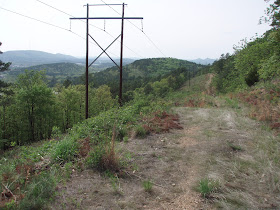
Trails along utility right-of-ways, or "Utilitrails", make great sense as well. Utility companies have to pay to regularly clear vegetation along their right-of-ways, putting in a paved or crushed gravel trail would decrease the amount of maintenance required along these routes and open up potential opportunities to split maintenance costs and work with city governments or trail-related volunteer organizations. Some of the trails at Hindman Park in Little Rock are great examples of Utilitrails as they were built and maintained in a partnership between the local wastewater utility and MBNA neighborhood association. The trails at Conner Park in Little Rock are connected to the trail in River Mountain Park by a power line.
 |
| Natural Location For A Trail - Power Line in West Little Rock With Nice View |
No comments:
Post a Comment