Pages

Monday, October 22, 2012

Fall is Here!

Fall has arrived and with it spectacular fall colors.  I've lived all over the country and I can safely say that Arkansas has the most beautiful fall colors around.  In my opinion, this is due to the wide variety of tree species we have and the fact that our mixed hardwood forests often have evergreens mixed in too.  In Indiana, fall is pure yellow due to the dominance of hickories, sugar maples, sycamores, and beech trees there.  In California it is either brown or stays green depending on where in the state you look.  Here, we have dogwoods, sweet gums, red maples, sassafras, sumac, black gums and a wide-variety of oaks that add an incredible range of stunning purples, pinks, reds, and oranges to the palette.  Many of these species can be found over much of the country, but not in the same concentrations and mixtures that Arkansas has.

This site posts frequent updates on fall colors across the state: http://www.arkansas.com/fall/fall-foliage/

Here is are some of my favorite places to view fall foliage:
Pinnacle Mountain State Park
Crystal Mountain in Flatside Pinnacle Wilderness near Lake Winona 
Mt. Magazine State Park
Petit Jean State Park
Highway 7
Highway 23
Queen Wilhelmina State Park


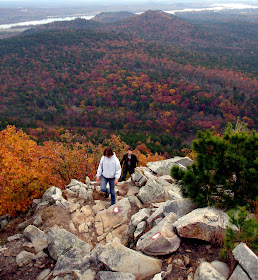
Fall at Pinnacle Mountain State Park, East Summit Trail, Little Rock, Arkansas. Photo by Johnnie Chamberlin

Sunday, October 21, 2012

Queen Wilhelmina State Park

Queen Wilhelmina State Park, located 13 miles northwest of Mena, has incredible views, great trails, and fun activities for kids.  While we didn't ride the mini-train or play putt-putt, we did take advantage of the campsite and trails around the park.  Like Mt. Magazine and Mt. Nebo, the trails at Queen Wilhelmina are pretty short but offer amazing views.  One exception to that, is the fact that the 223-mile Ouachita Trail passes through the park.  Read on for photos, a map, and brief summaries of the park's trails.

Ouachita Trail:  This impressively long trail (one of Arkansas' longest) runs right through the park.  Heading west from the tent camping area, the trail parallels the Talimena Scenic Drive.  Over the first 1.25 miles, you will come across nice vista points and an old pioneer graveyard.  Hiking another fifty miles will take you to the western end of the trail  in Talimena State Park in Oklahoma.  The trail also heads east from the lodge and works its way to Pinnacle Mountain State Park in Little Rock!  The eastern end of this trail is described in my book Trails of Central Arkansas.

Spring Trail:  The 0.5 mi. Spring Trail connects the camping area to the Wonder House and Amphitheater.  Campers can probably walk between those areas faster on the road, but this provides a more natural path with much less traffic.  I walked the trail early in the morning mostly to tire my dog out, so the fact that I didn't notice the spring shouldn't be taken as concrete evidence that it isn't there or isn't interesting.

Reservoir Trail:  This rocky trail heads west from the southern side of the lodge.  It gradually winds its way downhill to an old drained stone reservoir.  The round-trip hike is about 2/3 of a mile.  The walk-in campsite is located just off this trail.

Lover's Leap Trail:  This is probably the best trail in the park. The whole trail is a mile long, but if you just want the easiest way to the viewing platform, you can leave from the northeast side of the lodge, hike the third of a mile to the platform and head back the same way.

We had hoped to hike the nearby Black Fork Mountain Trail, a interesting spur off of the OT, but low clouds drove us to change up our plans and visit several wineries in Altus instead.
Monday, October 15, 2012

Crystal Bridges Museum Trails

Crystal Bridges Art Museum has an impressive network of miles and miles of diverse walking and biking trails that are well connected to the city's trail system and Compton Gardens.  Dogs are allowed on the trails ("but", I was told over the phone, "not in the museum".)  If you take a pet, you might want to look at a map online beforehand, as all of the outdoor map boxes were empty today.  

It has been a year since I last visited the trails (I've been to the museum a few times since then) and I'm glad I finally got to check them all out.  The fall foliage was starting to show up with hickories, red buds, dogwoods, and sassafras providing some amazing yellows, pinks, purples, and oranges that paired beautifully with the pines and still green oaks.  Multiple empty frames placed along the trails make a point I greatly appreciate, that nature provides us with limitless, ever-changing, incredible works of art that are free to everyone.  Each trail has its own unique character and perhaps surprisingly for someone who writes hiking books, my favorite was the very manicured...

Monday, October 1, 2012

Buffalo River - Gilbert to Maumee South

This weekend, Buddy and I went with some friends to float the Buffalo River from Gilbert to Maumee South.  Due to its length (12 miles), this stretch is less congested than more popular nearby routes between Tyler Bend, Highway 65, Shine Eye, and Gilbert.  In fact, we didn't see another boat on either day of our float at the end of September.  Of course this could have been due to the fact that the St. Joe gage was at 3.3', meaning the river was REALLY low and we had to walk a lot even in kayaks.  The float was incredibly beautiful, with views of some of the best bluffs to be seen on the Buffalo.  We camped near Red Bluff and the dogs had a great time running around, digging in the sand, and chasing skipped rocks.  At night we heard elk (maybe), a screech owl, whippoorwill, coyotes, and a couple loud splashes that I assume were river otters (any ideas what else?).  During the day we saw Great Blue Heron, some turtles, spotted gar, and several Kingfishers.